Throughout human history, civilisations have been named after the rivers along which they flourished: Indus Valley, Nile, Tigris-Euphrates. Many of these cultures later collapsed, partly because they could not manage their water needs properly.
Three recent books about Himalayan rivers look at their history and geography, and how they nourished civilisations downstream. The rivers gave birth to the world’s major religions, their waters and the mountains from which they sprang were revered.
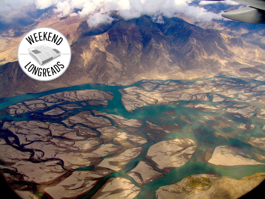
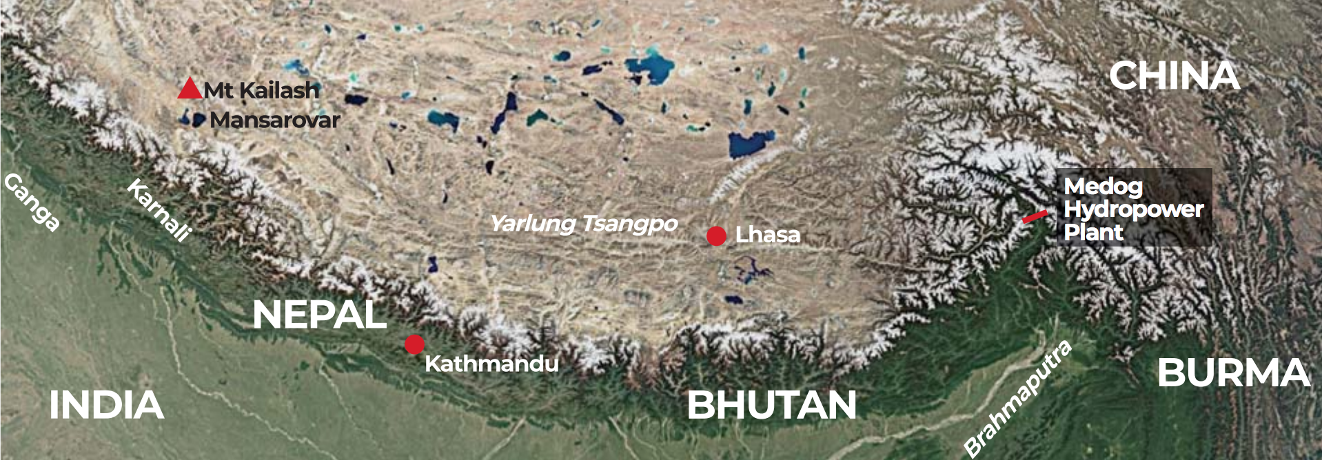
Mythology and geology converge in High Asia. Mt Kailash is holy to the Hindu, Jain, Buddhist and Bon faiths as the centre of the world and the abode of the gods. Indeed, from its vicinity emerge Asia’s great rivers: the Indus and Sutlej, Ganga and the Yarlung Tsangpo (Brahmaputra) and Karnali (Mapcha Tsangpo).
Legend has it that Kathmandu Valley was once a primordial lake drained by Manjushree who cut a mountain with his flaming sword. There is scientific evidence that the paleo lake was indeed emptied in stages starting 40,000 years ago after a tsunami unleashed by a major earthquake epicentred in Langtang.
The Bon faith describes the Tibetan Plateau being pushed up from a roiling primeval sea, confirming current evidence about the orogenesis of the Himalaya. In local lore, supernatural lha (animal deities) and lu (serpents, naga) moved from sea to land, just as the theory of evolution explains the emergence of early amphibians and land creatures.
In Rivers of the Asian Highlands: From Deep Time to the Climate Crisis, Himalayan historian Ruth Gamble and co-authors begin by tracing the genesis of the Himalaya, citing evidence that the Tibetan Plateau pre-dated the collision of the Indian and Eurasian plates 50 million years ago. Asia’s main rivers co-emerged with the mountains, their waters cutting canyons through rocks as they were uplifted.
The gigantic pileup acted as a moisture trap for the proto-monsoon, the rain and ice sculpting peaks as they rose. But so strong were tectonic forces that the uplift outpaced erosion on the Tibetan Plateau. These dynamic processes are still at work, but in many places across High Asia there is a new factor at play: modern infrastructure (like haphazard road-building in Nepal) is increasing erosion faster than the uplift rate.
‘This is an example of human action overcoming tectonics,’ write the authors in Rivers of the Asian Highlands, in which the chapters look at Himalayan rivers from a planetary scale, their socio-cultural histories, to present-day engineering to regulate them. An ongoing dam-building spree and anthropogenic climate breakdown combine to bring about the most rapid change the Himalaya and their rivers have seen for millions of years.
One example is the Medog Hydropower Station being built on the Yarlung Tsangpo at a bend on the Brahmaputra before it enters India. The river drops 2,000m within a 50km stretch, the gradient allowing it to generate 60,000MW — the biggest single hydroelectric plant in the world.
Gamble and the authors of Rivers of the Asian Highlands highlight the Gravitational Potential Energy (GPE) of the Himalaya that allows falling water to be converted into electricity. But GPE also unleashes landslides, rockfalls, avalanches, Glacial Lake Outburst Floods (GLOFs) and Landslide Lake Outburst Floods (LLOFs), the risks posed by them magnified by climate change and seismicity.
The Asian Highlands’ abundance of Gravitational Potential Energy (GPE) can support the region’s energy transition, but it needs to be produced in much less hazardous and less environmentally and socially impactful ways. The best means of doing this is through off-river, pumped-storage hydropower stations that back up solar and wind energy generators. Smaller projects such as this would also involve less risky tunneling and displacement.
Rivers of the Asian Highlands: From Deep Time to the Climate Crisis by Ruth Gamble, et al.
There is geological evidence that megafloods on Himalayan rivers are more responsible than mass wasting in weathering down the mountains. One big LLOF, for example, could ‘move 1,000 times more sediment than would otherwise be transported over millions of years’.
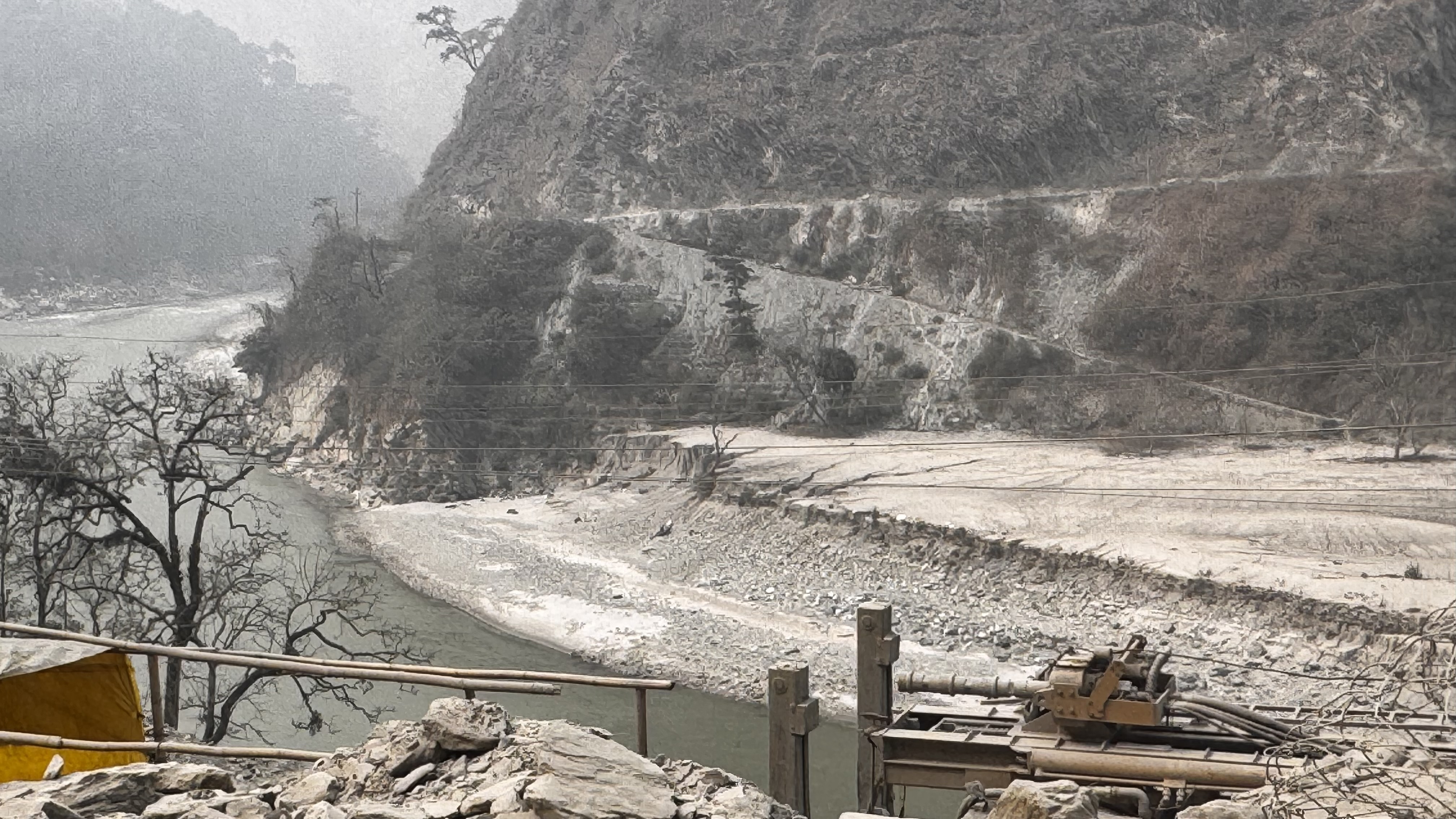
Permafrost melting in the Tibetan Plateau and inside moraines caused recent back-to-back GLOFs in Chamoli in the Indian Himalaya, Melamchi in Nepal, and the South Lhonak in Sikkim — all deadly disasters that together destroyed billions of dollars worth of infrastructure downstream.
Rivers of the Asian Highlands travels from deep time to the present climate crisis, taking readers through neatly divided chapters titled Mountain Rivers, Climatic Rivers, Frozen Rivers, Living Rivers, Human Rivers, Territorializing Rivers, Agricultural and Pastoral Rivers, even NGOs and Rivers.
Although the book’s title is about the ‘Asian highlands’, it focuses mainly on the Dri Chu (Yangtse) and Yarlung Tso (Brahmaputra). Readers looking for references to Nepal’s rivers will be disappointed, although there is quite a bit about Bhutan.
This is surprising because 70% of the annual flow in the Ganga is from tributaries in Nepal, some of them rivers like Karnali, Arun or Bhote Kosi that traverse the Tibetan rimlands. As demand for water and energy grows in the large and increasingly affluent population of north India, and climate breakdown melts Himalayan glaciers, storing monsoon runoff on reservoirs in Nepal is going to be the geopolitical issue of the next decades.
The chapter on NGOs and Rivers also fails to cite the work of Nepal’s civil society groups like the Alliance for Energy that built international solidarity in 1995 against the Arun III project on a river that starts in Tibet and flows into Nepal. Ultimately, the World Bank pulled out of the project and the Nepal government invested in smaller decentralised plants.
Today, a cascade of power plants are being built by Indian companies on the Arun which do not seem to have taken into account the 2023 Sikkim GLOF that swept away the $1 billion dollar Teesta III and destroyed other infrastructure. The World Bank itself is back with the Upper Arun project located directly below expanding glacial lakes in Tibet.
Despite geographical gaps, Rivers of the Asian Highlands reads like an encyclopedia of Himalayan rivers. The authors look at them not in isolation but as interconnected systems which need a multidisciplinary approach to study the geological, religio-cultural, infrastructure, climate and ecosystem services aspects of catchments.
Mt Kailash (Kang Rinpoche) is a case in point. It is fascinating to think that it was part of a mountain range even before the collision of the continents that formed the Himalaya, and was probably buried in ice 3km thick till 15,000 years ago during the Last Glacial Maximum.
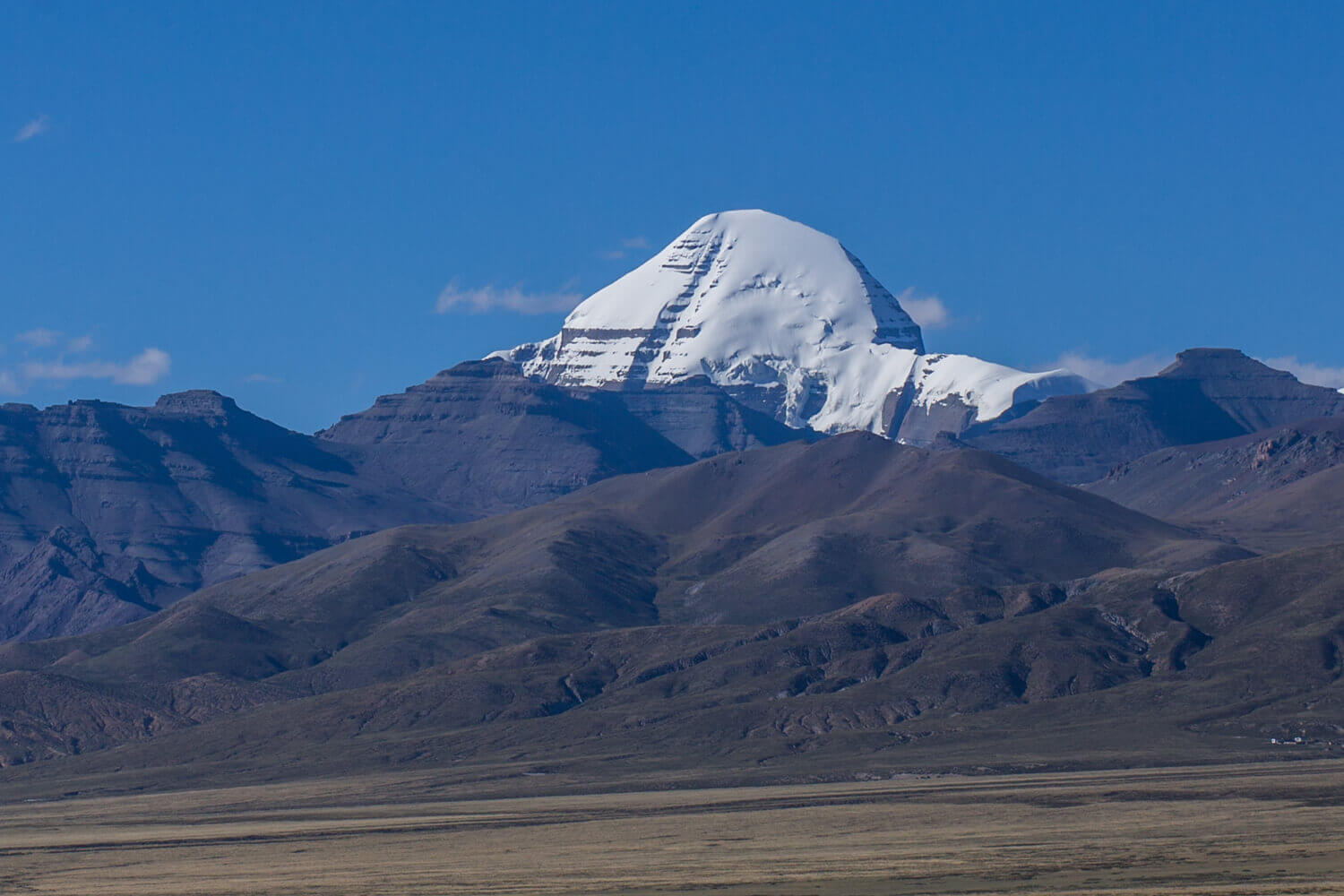
Lake Mansarovar and Mt Kailash are also the subject of the new Nepali language book छालबाटो (Road by the Waves) by environmental journalist Ramesh Bhushal in which he walked, rafted and drove from the source of the Karnali in Tibet, right through 500km of western Nepal, and on to India where the river meets the Ganga.
In his entourage is activist, Megh Ale, who is on a campaign to stop dams and infrastructure on Nepal’s longest and only free-flowing river. The book profiles his lonely upstream struggle to conserve the country’s rivers. “We worship rivers, but we don’t love them,” laments Ale.
Bhushal’s book is as much about the landscape of this transboundary river as it is about the people he meets along the way, and their relationship with a river that most regard as a curse keeping them poor because they believe it flows out of Rakshas Tal (Lagngar Tso) in Tibet, regarded as a lake of demons, unlike the sacred Mansarovar nearby.
The expedition is out to prove that the Karnali River actually starts in the mountains 50km southwest of the Mansarovar (Mapamyu Tso) at the
. The Indus is called Sengge (Lion), Sutlej is Langchen (elephant) and the Brahmaputra is Tamchok (horse), all starting within 60km of Mansarovar but flowing out in different directions.“I have visited hundreds of rivers around the world, but for some reason I have never seen a river as beautiful as the Karnali. One day I would like to visit its source.”
River conservation activist Megh Ale quoted in छालबाटो by Ramesh Bhusal.
But all this reverence for the mountains and rivers may not be enough to save the region from the impact of climate breakdown. Heat stress in the Subcontinent will coincide with a shortage of water in the coming decades.
Sunil Amrith in his 2019 book, Unruly Waters: How Mountain Rivers and Monsoons Have Shaped South Asia’s History takes a broader look at how geotectonics, geopolitics, colonialism and nationalism have determined the relations between human beings and rivers.
The Himalayan water cycle starts from monsoon moisture that precipitates with orographic uplift along the mountains, atmospheric rivers unleash cloudbursts, ground water emerges from springs that join up to flow down to rivers and the ocean. The Third Pole is the biggest repository of fresh water stored as ice after the polar regions. But it is a hotspot both because of the climate crisis and geopolitical tensions, which impacts on river basin cooperation, early warning data sharing, and ultimately in mitigation of greenhouse gas emission and planning for new risks faced by infrastructure.
After independence, India adopted the colonial extraction model for rivers. Inaugurating the Bhakra-Nangal Dam in 1953, Jawaharlal Nehru called it “a temple of modern India … worthy of worship’. Gamble also alludes to this in her book about the European attitude about rivers as a resource to be ‘enclosed, extracted, scrutinised, commodified’.
Amrith profiles the work of Sir Arthur Cotton who was building canals linking rivers in British India at about the same time his contemporaries like botanist Joseph Dalton-Hooker were exploring the Teesta and other rivers in the Himalaya to catalogue new plant species. India's current National River Linking Project that would join 37 rivers with 9,000km of canals builds on Cotton’s early work.
If there is one consistent lesson in Unruly Waters, it is that water management never has been, and can never be, a purely technical or a scientific question; neither can it be addressed on a purely national scale … the battle continues to understand the monsoons and mountain rivers that shape Asia.
Unruly Waters: How Mountain Rivers and Monsoons Have Shaped South Asia’s History by Sunil Amrith
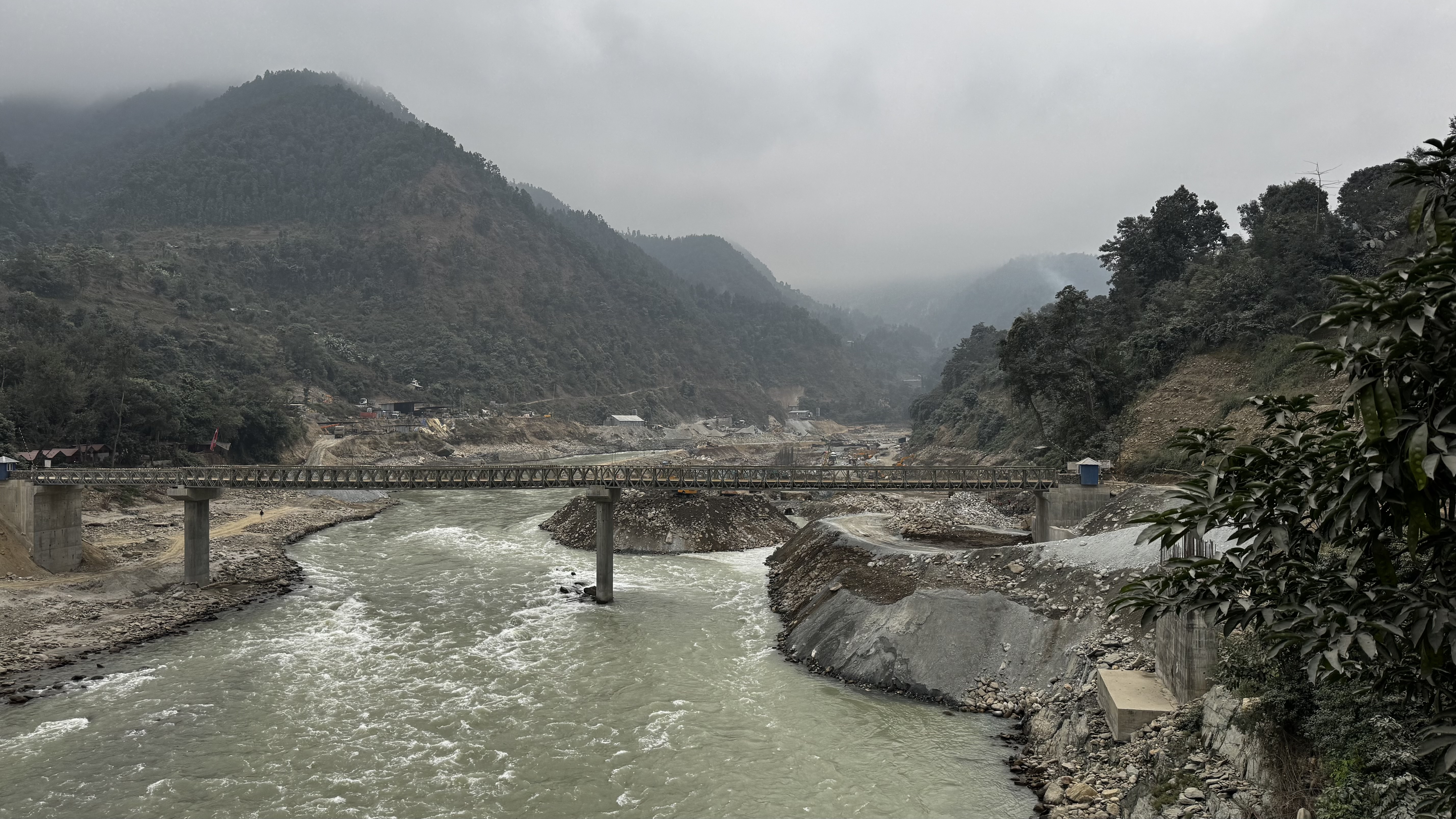
And in Nepal, hydropower has become the holy grail as the government unveiled an Energy Development Roadmap to generate 28,500MW by 2035 at a cumulative cost of nearly $50billion. This means no river in Nepal will be left free-flowing. The Trisuli along the Prithvi Highway is being dammed for only 100MW of power, destroying the most scenic part of a river that has rapids famous internationally for white water rafters. Even before it was completed, the dam site suffered Rs200 million in damage in last September’s flood.
In Sikkim, there is strong local opposition to rebuild Teesta III but investors are looking at the huge economic windfall from the river as it drops from 5,000m below Kangchenjunga to 300m within 80km — one of the highest Gravitational Potential Energy of any river in the world.
Besides Nepal and Bhutan, the ‘watersheds’ of the Himalaya are turning into ‘powersheds’ as India and China compete for hydro-hegemony. India is said to be planning to dam the Brahmaputra to offset the disruption caused by China’s Medog Dam upstream (see map, below).
The thread running through all three books is the need to recognise the ecosystem services that the inhabitants of High Asia provide by protecting our rivers. Not all rivers need to be monetised, conserving rivers and the cultures they retain protects a nation’s natural wealth into the future as the humans of High Asia try to survive climate breakdown.
The highlands will be under even more pressure in the coming decades as people in the plains migrate en masse to higher latitudes or higher altitudes to escape deadly heat and ocean expansion.