
 |
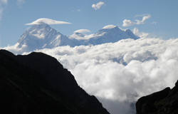
In his fascinating book 'The Great Himalaya Trail - A Pictorial Guide', Robin Boustead uses stunning photographs, compelling storytelling and section route descriptions to describe the highest feasible route across Nepal. The large format pictures offer an intriguing insight into the first expedition to trek and map the Great Himalaya Trail. It crosses every one of Nepal's mighty mountain ranges, from Kanchenjunga in the east to Saipal in the west. Folklore combines with descriptions of the communities encountered to give the reader an intimate glimpse into the lives of mountain people. The series of interlinking trekking maps and graphical trail profiles provide enough detail for anyone to begin planning their own Great Himalaya Trail adventure.
In this week's issue of Nepali Times, Robin Boustead writes about his adventures on the Great Himalaya Trail. Here is a preview:
If there is a trekking 'holy grail', it is a route through the remotest peaks of the Great Himalaya Range that joins all the major trekking regions in Nepal. Following five years of research treks, the Nepali section of the Great Himalaya Trail is now a reality. Starting in September 2008 in Kanchenjunga and ending in July this year in the Api Himal, Pema Sherpa and I became the first people to traverse the entire length of the Nepal Himalaya. In doing so we traversed some of the most amazing mountain scenery on the planet and discovered an incredible wealth of ethnic and natural diversity. The result is an extreme trekking trail over 162 days with more than 150,000 metres of climbing and descending, a proposition sure to tempt adventurous trekkers. Over the next couple of years, I will be trekking through the Eastern and Western Himalaya to complete a trans-Himalayan trail over 4000km that will take between 16-18 months to trek.
To read the full article, please see this Friday's Nepali Times.