
Going by the numbers Nepal uses to define danger, the flood of 26 August was unremarkable.
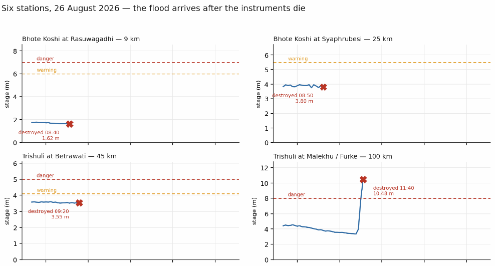
At 8:40am on 26 August, the automatic gauge on the Bhote Kosi on Nepal’s border with China recorded the water level at 1.62m. It was low, and falling.
That was the last reading of the Rasuwagadi station. The wall of water coming down the Lhende Khola destroyed the equipment before the next reading was due. The gauge at Syaphrubesi 15km downstream died when the water level reached 3.8m. Betrawati was knocked out at 3.55m. These were all below the prescribed Amber warning thresholds.
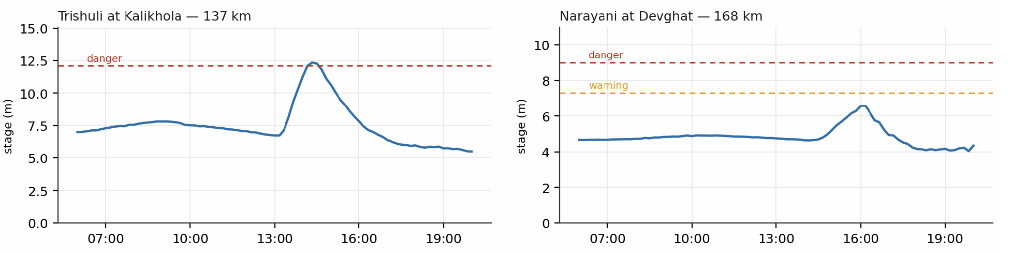
It was 4pm by the time the flood peaked at 6.57m in Devghat, 170km downstream on the Narayani River. That was the highest point measured during this flood event, but still below the Amber warning level of 7.3m (see charts).
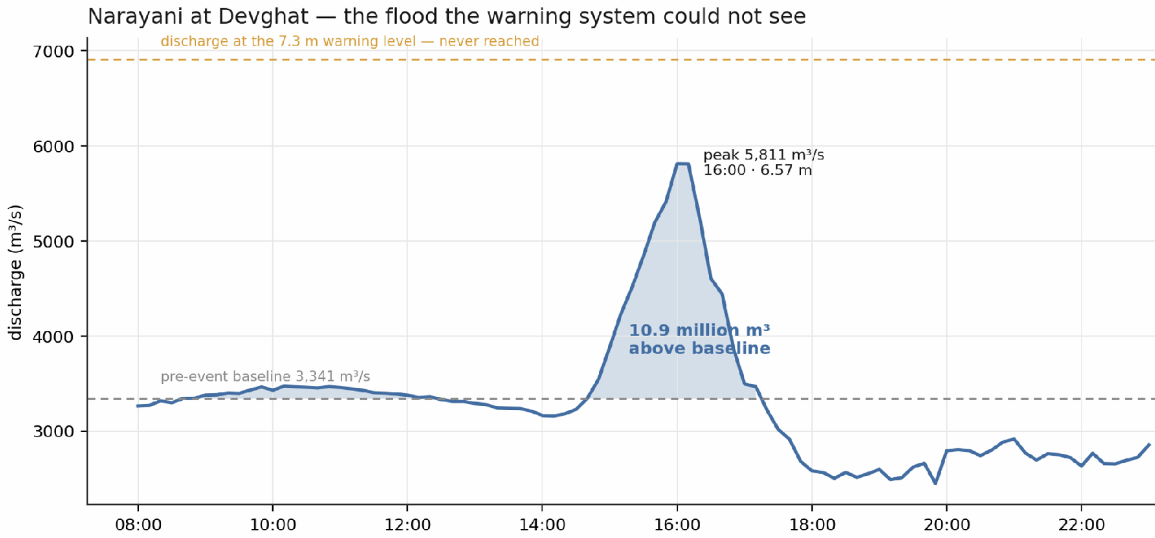
Devghat is the last gauge on the river, and it stayed green throughout the flood of 26 August.
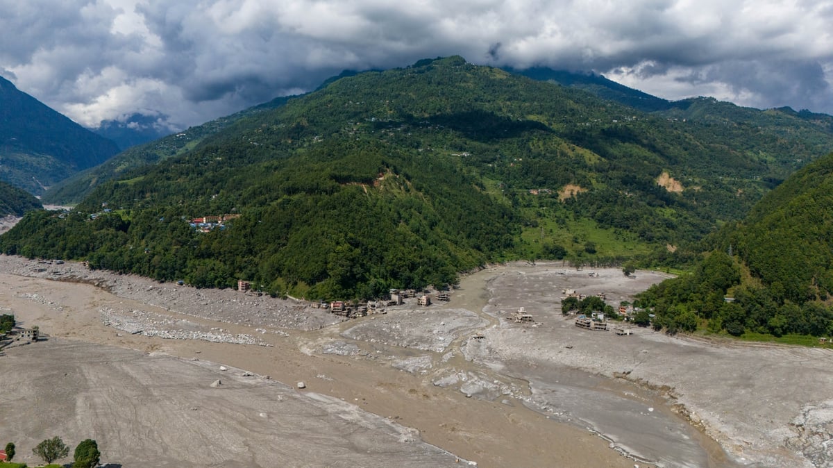
But upstream, hundreds of people had already been swept away the fury of the mudflow. Between Rasuwa to Chitwan, 22 concrete bridges were washed away, a dozen hydropower plants were damaged or destroyed, as were four of the flood monitoring stations built to protect them.
The Flood Forecasting Division’s findings, published the next morning on 27 August, registered peak flow at Devghat at 5,850 cubic metres per second. This is a kind of flood that comes once every two to three years, meaning that Nepal’s deadliest and most destructive flood in recent history arrived at the last measuring station on the river as a fairly ordinary event.
Nepal’s flood gauges are designed to warn us about monsoon rains that drain a catchment, and raise river levels to seasonal heights. The warning levels are set based on that history, and for that purpose it works well.
The new normal does not mimic that history. This was an outlier event because the mud flow was not triggered by rainfall, it began with an ice-rock avalanche, entered a gorge as a wall of debris and spent its height as it travelled.
Over its 168km course to Devghat, the river had been joined and diluted by the Budi Gandaki, Marsyangdi, Seti and Kali Gandaki and other tributaries (map). And by that time in the afternoon the water level was not very high. But it did rise fast.
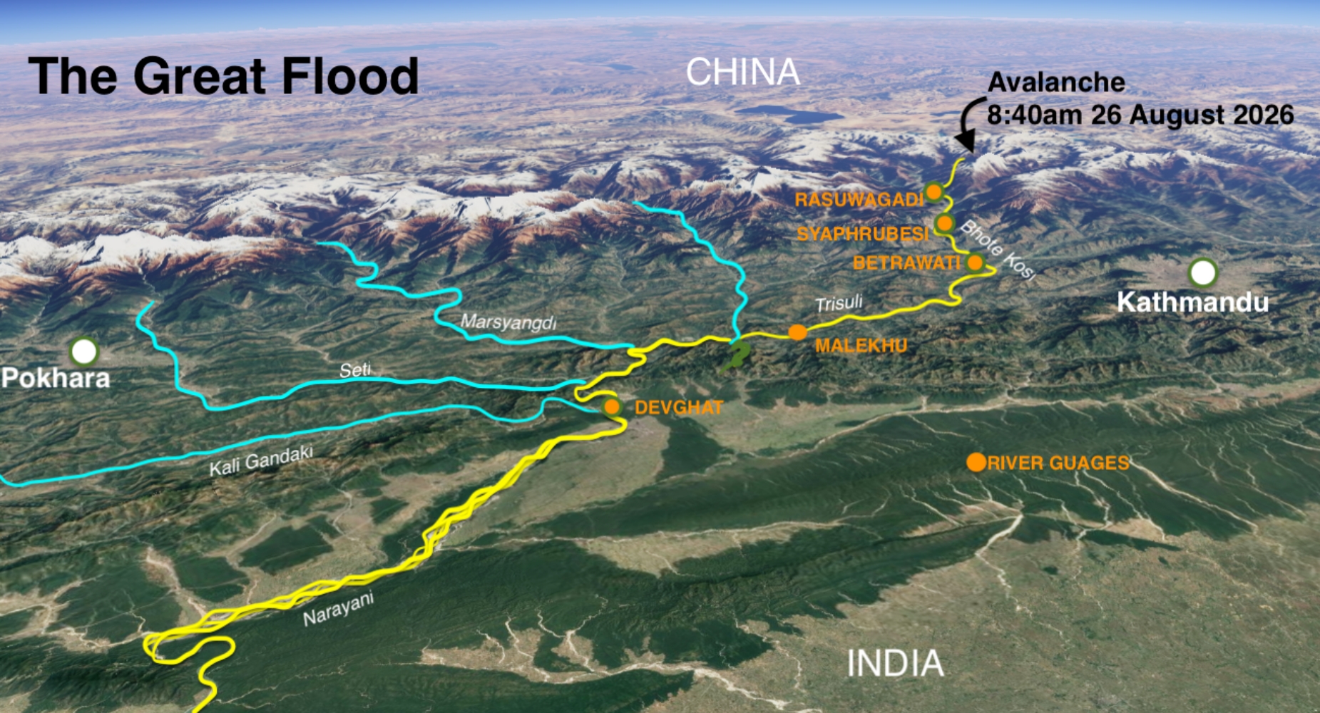
The Narayani rose almost 2m within two hours, on a day it had been falling. Our gauges simply ask one question of a river: how high are you? They do not ask: how quickly are you rising? That has to be computed in real time.
That morning, three stations went out with calm numbers on the screens at the monitoring station — way below their Red and Amber levels. The first threshold anywhere on the network was only crossed 100km downstream at Malekhu at 11:20am — nearly three hours after the flood crossed into Nepal. At Malekhu the water level rose almost 4m between one ten-minute report and the next and crossed the Red alert mark.
MASS SMS
It was 9:00am when the Flood Forecasting Division learnt of the flood not by station reading, but by telephone call from the District Administration Office in Dhunche, and later from an observer in Betrawati.
By 9:15am the first alerts were out. Within one minute, 679,295 warning text messages had been sent through Nepal Telecom and Ncell, and the alerts stayed ahead of the water all the way down to Devghat.
The mass SMS saved a lot of lives. An alert school principal in Bidur evacuated his 1,643 students to higher ground before the debris flow arrived. We have to give credit where it is due — that one phone call saved thousands of lives.
At 8:00am that morning, an hour before the telephone rang, Flood Forecast Bulletin for 25 August had been sent out: it listed Rasuwa, Nuwakot, Dhading and Gorkha, along with Dolakha, Sindhupalchok, Lamjung and Tanahun district at high flash-flood risk along small rivers and forecast a notable rise on the Trisuli at Betrawati.
But these bulletins go out every day, and during the monsoon do not usually raise alarm bells. The daily alerts forecast rain and what it will do to rivers, it cannot see an avalanche-induced mud tsunami 80m high in places coming down the river.
The night before, at 9:10pm, the Phalakhu Khola, which joins the Trisuli at Betrawati, had crossed its own warning level and was still rising. None of this gave any hint of the disaster to come the next day.
On the morning that mattered most, the districts in the flood’s path were Code Orange in the government’s flood warning bulletin. But such warnings are quite common in the rainy season, and many took it as a matter of course.
The rules for Orange Alert response do not lay out precise procedures for the Chief District Officers, municipality chairs, school principals, hydropower operators, bus companies on the Prithvi Highway. The 26 August bulletin put 30 districts and adjoining ones under some level of risk — an ordinary count for an ordinary monsoon morning.
A warning issued every day, carrying no responsibility for anyone, is not a warning. It is a weather forecast. We have been here before — almost exactly a year ago on 8 July 2025, a flood came down this same gorge, killed 18 people, washed away the Miteri Bridge at the border, the same power plants and the same highway.
In the 13 months since then, no new protocols were laid down to make flood warnings more effective. In the past week, the Division has asked for a review of the forecasting and warning systems, and the following steps may be worth considering before the next disaster hits:
1. When to ring the bell. Every flood gauge station reads water levels its river six times an hour, so the speed of a rise is already in the data. Add a second trigger beside the height thresholds that fires when a river rises abnormally fast. With this, Malekhu could have raised the alarm before 11:30 and Devghat by mid-afternoon.
2. Who does what in an Amber Alert. A colour code is a command only if everyone agreed beforehand what it commands. Nepal needs one national protocol that ties each warning level to fixed duties for every tier of government and every actor on a river. Which office convenes, which roads and intakes close, which settlements move. Federal, provincial, district, municipality have same message.
The Disaster Risk Reduction and Management Act put committees one in every province, district and local government, but the link between the DHM (Department of Hydrology and Meteorology) Red-Amber-Green alerts and their duties has never been written down.
No single ministry can decree that link, and nobody can improvise it mid-flood. It must be settled once, in advance, by all of them together. All three tiers of government, the security apparatus, utilities, schools, the media must adopt it as a national consensus, so that on the next Amber Alert no one is confused about how to react. They do what was decided.
3. What is the cost of warning. The budget for the DHM that monitors the river gauges has seen its budget slashed from Rs765 million to Rs338 million in three years. Now, it has been moved to another ministry. The Infrastructure Minister’s same-day estimate puts the damage from this disaster at Rs200 billion. A year of flood preparedness and early warning costs Nepal roughly one six-hundredth of what this one flood cost.
On 26 August, SMS flood warnings went to 679,295 pockets within 16 minutes of one telephone call by an alert official. Next, we have to ask: you have been warned, now what? We have to settle that answer in advance so that warnings do not become routine enough for people who get them to ignore.
Leave it open, and the next flood on this or another river will mean another unheeded warning, and another disaster.
Devesh Belbase is a Kathmandu-based water policy and governance expert.
If you are looking to support communities affected by the flood in Nepal, donate to the Prime Minister’s Disaster Relief Fund here. Additional information here.