
On Thursday in New York, Prime Minister Balendra Shah addresses the UN General Assembly. He has said the Bhote Kosi-Trisuli disaster happened because of climate change, and that answering it is a global responsibility rather than only a national one.
He is right that we cannot carry this bill alone. But the case will meet a question the world is entitled to ask, and we should answer it: What did Nepal do with the plan it already had?
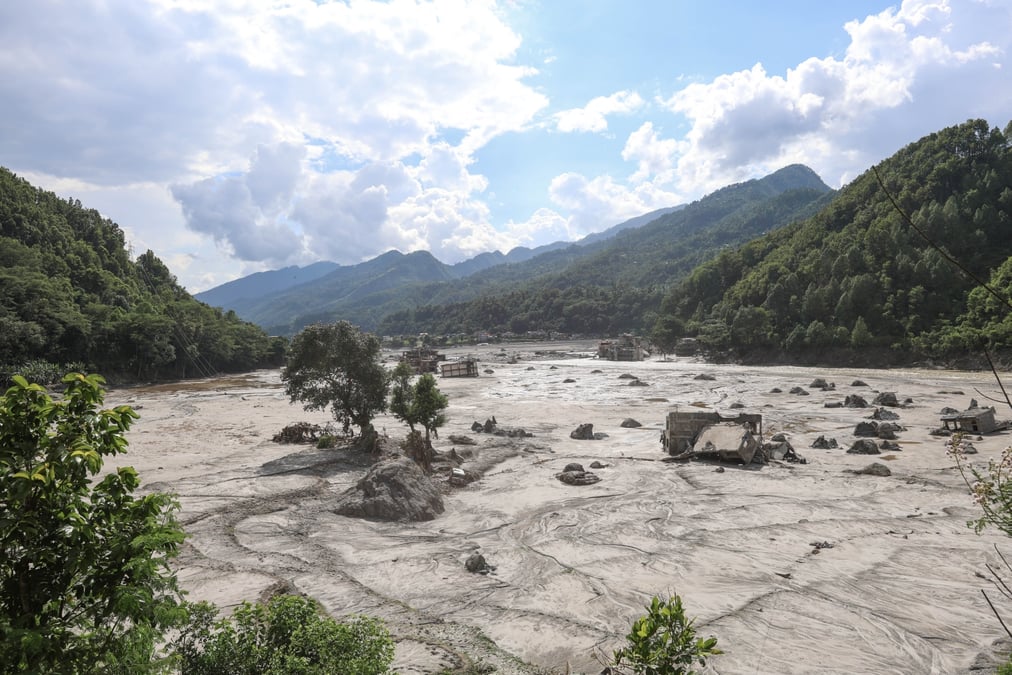
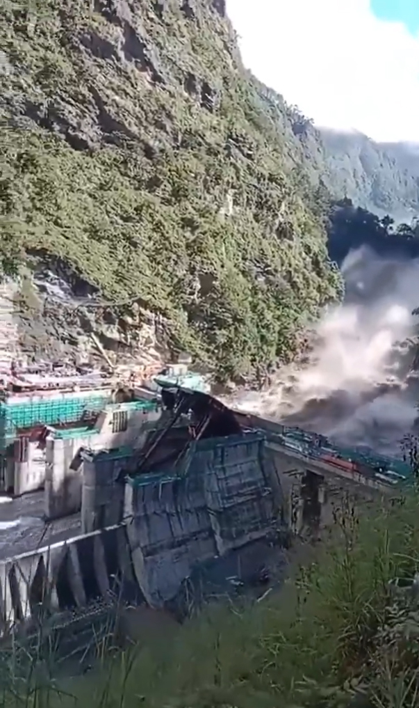
At 08:37 on 26 August, a slope below Tsangbu Ri in the Langtang Lirung massif gave way. Roughly two square kilometres of rock wall and glacier ice fell about 1,400m from 5,150 metres to the valley floor. Frictional heat liquefied much of the ice, turning rock and snow into a slurry moving at an average of 188km/h.
At 08:44 it reached Rasuwagadi, 22 km in seven minutes. No warning system in any country would have closed that gap.
In the households of Rasuwa that keep the rites, the counting is also in sevens. We are in the fifth of them, and the forty-ninth day falls in the middle of October. Many families have had to use effigies of holy grass in place of bodies never found.
Nepal had planned for floods, and for two kinds: a glacial lake outburst flood (GLOF) and monsoon rivers rising. But on 26 August a mountain failed and a flood whose source our plan does not describe ran 200km down the Trisuli into six districts.
Here is the part that should trouble us most: a warning was issued. The Syaprubesi gauge stopped transmitting at 08:50. By 09:15 the Department of Hydrology and Meteorology (DHM) had confirmed a major flood wave and issued a warning.
The water reached Galchi at 10:28 and Devghat at 15:20. Downstream, it does not matter whether the flood was released by a GLOF or a mountain collapse: a wave is a wave. The World Weather Attribution rapid assessment on 17 September found that nothing could have helped in the worst-hit places, and that Nepal’s existing warning systems demonstrably saved lives downstream.
The warning system was not blind to the flood, it was blind to the mountain. And in the six hours it had, it could not turn what it knew into what people did.
At a secondary school in Nuwakot, the headteacher moved 900 children to high ground about 10 minutes ahead of the water, acting on four informal warnings, one of them a call from Betrawati upstream. He was right, the children are alive, but nothing in the system helped him be right.
He was following no protocol, because there is none. The DHM can forecast and warn, but it cannot order anyone to move, and no rule turns a forecast into an evacuation. In the floods of late September 2024, more than 200 died across central Nepal despite advisories issued days in advance.
The National Adaptation Plan (NAP) adopted in 2021 and running to 2050 is a serious document: 64 costed programs, a sectoral hazard assessment, Asia’s first national adaptation plan financed by the Green Climate Fund. A regional study now under review finds that Nepal and Pakistan each set out 19 glacier-related adaptation measures, more than any other country in the Hindu Kush-Himalaya.
Most of Pakistan’s measures are now complete or under way. Most of ours are still planned. Our NAP rates GLOFs and avalanches as likely to increase, and puts the cost of reducing that risk in the Gandaki, Koshi and Karnali basins at $1 billion by 2030.
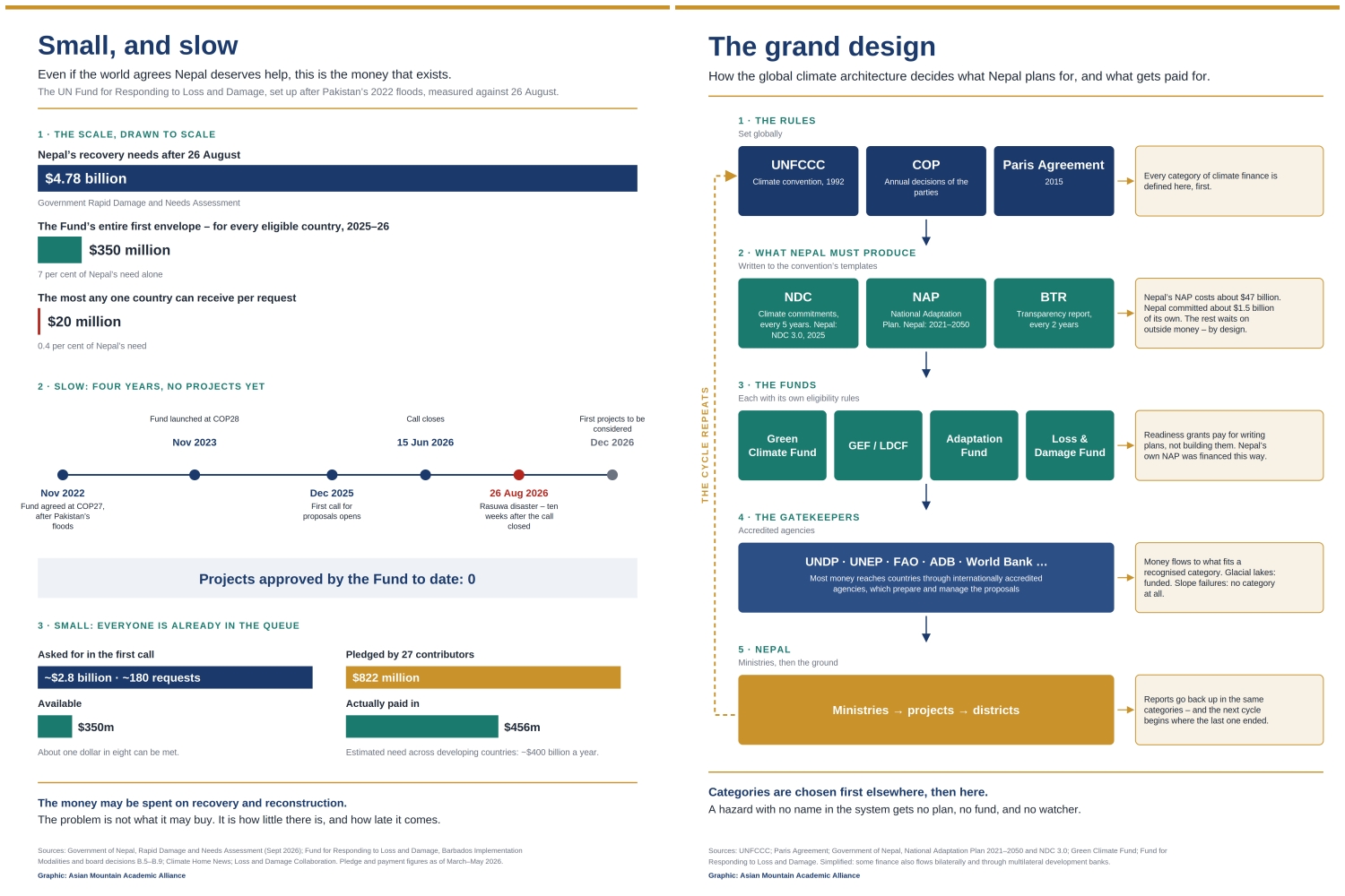
That figure was never a Nepali commitment: of the roughly $47 billion the plan costs, Nepal undertook to find $1.5 billion at home, the rest was always conditional on international finance, as the convention’s own architecture intends.
LOOKING FOR LAKES
The Trisuli is in the Gandaki. But every action in that plan is a lake action: identify dangerous lakes, assess moraine dams, lower water levels, install lake sensors. Not one of them points at a slope.
Satellite radar shows the source area accelerating from the middle of June, and about 15 centimetres of bedrock deformation over four months in late 2025. The seismic signature of the failure was recorded within seconds by networks in China and by the international catalogue. That one existed in real time and nobody was reading it.
On 7 February 2021, some 27 million cubic metres of rock and ice detached from Ronti Peak above the Chamoli valley, in the Indian Himalaya. No lake, no monsoon, it was mid-winter. There were 204 people dead or missing, most of them workers at two hydropower projects under construction, some trapped in a tunnel at Tapovan.
Fifty-three scientists published the analysis in the journal Science four months later, and closed by asking whether the Himalaya was being adequately monitored. Later work found the crack on Ronti Peak widening in satellite images from 2018, three years before it gave way. The seeing had been done, but nobody had been asked to look.
Nepal submitted the NAP to the United Nations in October 2021. But five and a half years on, Nepal’s official picture of its own mountain hazard still looks for lakes and rain and nothing else. The NAP provides for its own correction: a vulnerability and risk assessment updated every five years, and a review of implementation on the same cycle.
On 20 August, six days before the mountain fell, a call went out for consultants to update the 2021 assessment, funded from abroad and commissioned not because the NAP required it but because a report was due to the climate convention. Proposals closed four days after Rasuwagadi, and the work had not begun. No review of the NAP’s implementation has been published.
Nepal did ask for the money. The NAP put glacial lake risk reduction and early warning at $1 billion by 2030. Nepal has received around $45 million for the purpose, under 5% of it. Pakistan has been running glacial lake projects since 2011, first on Adaptation Fund money and then on Green Climate Fund money, both through UNDP.
Of all bilateral glacier and lake funding across the Hindu Kush Himalaya since 2002, more than half has gone to Pakistan. Nepal’s first equivalent – same fund, same agency, same category – was approved only in July last year, and covers four glacial lakes – Thulagi, Lower Barun, Lumding Tsho and Hongu 2. None of them are on the Trisuli.
Nothing about the ice above our valleys explains the 14-year gap. Money moves where a category has been recognised, and recognition is granted elsewhere.
Money was short, knowledge was not. The damage assessment before the government was led by the National Planning Commission with 15 officials across nine agencies, and within days of the collapse, Nepali and international scientists had established its source and sequence from imagery anyone may download, working with Chinese colleagues who shared photographs of the failure zone.
What does not exist is an institution mandated to commission that work before an event. Nepal has no common alerting protocol, and no warning system for the hydropower sector, which is the infrastructure this flood destroyed.
Count the cost of that omission: damage assessment puts recovery needs at 12% of last year’s national income, more than half of that in energy. Public hydropower projects were uninsured, so taxpayers carry the loss. We will now build after the flood, at that price, what we did not build before it. The money will mostly be borrowed.
In August, our finance and environment ministers asked the Fund for Responding to Loss and Damage to act ‘rapidly, directly and effectively’. That request was right to make, but climate finance is slow as well as small: the Fund’s entire first allocation, shared among every eligible country on earth, is smaller than the bill for this one disaster.
And the next one may not be a flood at all. What came down the Trisuli began as mountainside giving way and became an avalanche, an air blast more than a kilometre across, a slurry of ice melted by its own falling, a debris flow, and a landslide that dammed the river behind it. We called it a flood because that was the only word we had.
None of this is an argument against the NAP, and it is not a failure of Nepali effort or expertise. It is a failure of categorisation. Hazard in the Himalaya is not a single object a plan either sees or misses, it is sorted into kinds, and the kinds are ranked.
GLOF is a funded category, with a database, an inventory and a line in every national report. Rock and ice avalanche in dry conditions is not a category at all in our planning instruments. What fell on 26 August was not unforeseen. It was unclassified.
Categories are chosen, first elsewhere, then here. The plan was costed for a fund that disburses against recognised categories, and the assessment is being revised because a report is due to a convention that asks in those categories.
The region’s principal record of these disasters sits in the HKH Regional Information System, and it is a record of lake bursts: 697 of them stretching back to 1833, while the same platform holds no permafrost data at all and, asked for avalanches in Langtang National Park in 2015, returns none – the year the village was buried.
The WWA assessment describes a catastrophic rock-ice avalanche at Langtang Lirung that same year. To be visible in that system, a disaster must first be the right kind of disaster. The selectivity is not ours, the consequences are.
None of the five actions we propose requires anything to be invented. What they need is a decision and a budget line, and the recovery package already holds most of the money. Nor does any of these five actions depend on settling whether climate change caused this collapse:
1. Publish the implementation review and the updated assessment, put cascading hazards in the taxonomy where lakes now sit alone, and name a standing custodian for the plan – an office, not a person, with a duty to report on the cycle.
2. Adopt a common alerting protocol and a warning system for the hydropower sector. Give one agency the legal authority to order an evacuation based on a forecast, and write the procedure that binds it.
3. Build the inventory of slopes that could fail next, and the seismic monitoring to watch them.
4. Legislate for custody of our own hazard record: data generated on Nepali territory should be deposited with a Nepali public institution, and the classification it is filed under should be ours to amend.
5. Agree a data-sharing and joint warning mechanism with China: of the 47 glacial lakes judged dangerous to Nepal, 25 sit inside Tibet. We hold such agreements with India and Bangladesh.
The WWA assessment finds that human-caused warming added about 1.5°C to the July and August temperatures at the site of the failure, and that Langtang Lirung’s ice has been receding some four times faster since 2010 than in the two centuries before.
It does not claim the slope would have held in a cooler world. It says the conditions around it have changed, measurably, and because of human activity. The deeper task, though, is not a list. It is who does the naming.
A hazard with no name in the plan gets no instrument, no budget and no watcher. Naming decides what is seen, and what is seen decides who lives. The scientists who read the imagery from the north slope of Tsangbu Ri within hours are in Kathmandu. What they lacked was not capacity but standing: the authority to set the categories their own state, and its funders, plan by.
The Prime Minister speaks for Nepal in New York this week. The rest of the speaking has to be done here, by Nepali scientists, in terms we set ourselves. The knowledge is here, the knowers are here. The naming is the one part of this that nobody else can, or should, do for us.
The mountains are not waiting. Neither are the families: in three weeks the 49th day will come, the crossing will be complete, and the dead of Rasuwa will be beyond anything we can do for them. The living along that river will not wait.
The regional study cited in this article is under review, led by Dipesh Chapagain, a senior scientist in the Global Mountain Safeguard Research (GLOMOS) programme at the United Nations University Institute for Environment and Human Security (UNU-EHS).
Asian Mountain Academic Alliance (AMAA) is a non-profit organisation registered in Switzerland. Its Asia Coordination Office operates virtually. Tri Ratna Bajracharya is President, AMAA and Truong Huyen-Chi is Director, AMAA Asia Coordination Office. Both authors live in Kathmandu.