
Kathmandu Valley may be consumed by urban sprawl, but the historic core of Patan has changed little in the last 400 years. Destroyed and rebuilt serval times over the centuries, the seat of the Malla kings is a jewel in the crown of Nepal’s heritage.
Now, the next generation of Nepali school students have found an exciting and fun way to find out more about the history of their geography.
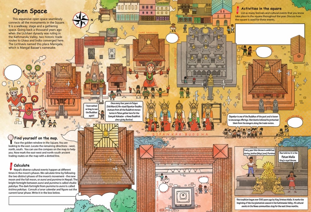
The Kathmandu Valley Preservation Trust (KVPT) has launched a series of interactive maps with bilingual explanations meant for students on school excursions called ‘Let’s Discover Patan Durbar Square’.
The maps are distributed to schools to use during their study trips and prompt students to draw what they see, or create something new. One activity asks students to dream up a new monument in the square that respects heritage but would endure, while keeping in mind material of cultural significance.
Another activity asks students to hunt for particular elements in the carvings or pillars, forcing them to pay close attention to the details. Another task tells them to count the number of gilded gajur pinnacles on Krishna Mandir, and then draw them.
Read also: A portal into Patan’s past and present, Prakriti Kandel
Creative activities vary in complexity and difficulty and challenge the students to also think beyond what they see: one asks students to ‘imagine the underground pipes and the main source of water at Manga Hiti’.
The colourful maps come in A4-size booklets and are part of an Educational Outreach project started in 2017 by the art festival Kathmandu Triennale, and now taken over by KVPT. The English and Nepali text on a map guides young visitors around the Patan Darbar Complex. The booklet reflects the Malla era aesthetics of the palace square.
“We hope that the maps will extend the outreach to schools and students with first-hand interaction with this historic and cultural site,” says Sophia L Pandé at KVPT, which has been involved in the restoration of the Valley’s heritage, especially after the 2015 earthquake.
It aims to inspire a sense of responsibility for conservation from a young age, and the third edition of the map project was supported by the US Embassy, and the one before that by the New Zealand High Commission.
Read also: Preserving Patan post-earthquake, Claire Burket

One of the creators of the maps, Rishi Amatya, says the Patan Darbar Complex is an open space that can foster creativity and give culture inter-generational continuity. After every earthquake, the palace complex has also provided safety and shelter to the people of Patan.
“Around the year, the open spaces of Patan Darbar Square serve as the traditional stage for jatras,” explains Amatya, “so it is not just the temples and monuments but also the intangible heritage that makes this place so important.”
Amatya worked alongside editor Sharareh Bajracharya and illustrator Suman Maharjan on the Let’s Discover Patan Durbar Square series. Maharjan’s illustrations make the booklets introspective and vibrant, which even adults will find interesting and informative. With his extensive experience drawing picture books, Nepali elements feature heavily in his work.
The drawings balance faithful detail in the temples with a playful, cartoon-like style in depicting people and activities. The booklets are printed in high-quality and do the drawings justice, and it is a physical copy that students can pick up at the Patan Museum.
Read also: Patan heritage in fantasy fiction, Trishagni Sakya
There is a lot of work that goes into making the maps, and it starts with Amatya’s research. Being a local he has a lot of knowledge passed down from his forebears, as well as first-hand stories and history books. He then researches monuments and develops a narrative that fits a theme.
The Keshav Narayan Chok hosts the Hindu god and columns from when it was part of a Buddhist Vihar. There are Lichhavi-era stone columns and reminders of when the square was the seat of the Mallas. The dome roof structures point to post-earthquake Rana influences. In the first map, characters get a bird's-eye view of Sundari Chok and Mul Chok on Garuda’s back.
The project requires the writer, editor, and illustrator to work closely, to decide what to include and what to leave out. “Rishi and I spent a lot of time walking around Darbar Square to get the drawings right,” says Maharjan.
The effectiveness of the maps were obvious during a recent tour for students from Adarsha Kanya Niketan, a school adjacent to the museum. The Trust also provides transport for schools that come from further away and Amatya acts as a guide, training other guides.
Read also: Itumbaha's living museum, Sahina Shrestha
To book tours, contact Patan Museum or the Kathmandu Valley Preservation Trust.