
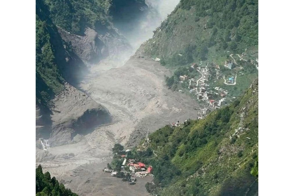
Nepal sits downstream from the Tibetan Plateau in China, and the country has a blind spot when it comes to disaster preparedness.
A disaster upstream becomes a disaster downstream, yet much of Nepal’s flood preparedness begins once the two Bhote Kosis, Karnali or the Arun enter Nepal.
The Tibetan Plateau feeds some of Asia's major rivers, and its glaciers, glacial lakes, permafrost, and terrain are changing as the climate warms. For Nepal, what happens on the other side of the Himalaya can come down as a flood that kills people and destroys infrastructure.
Both Bhote Kosis start in Tibet, one crosses into Nepal at Kodari and the other into Rasuwa. In both cases, the steep rivers flow through deep gorges and past settlements, hydropower projects, and roads that form the two main Nepal-China trade routes.
The problem is not just that Nepal is vulnerable to floods. It is that sometimes, the hazards that become floods in Nepal begin somewhere else as they did last year and again this year on the same river.
Preparing for them requires information, research, and communication that can cross the same border the river does. The Bhote Kosi floods have demonstrated this vulnerability in two consecutive monsoons.
On July 8, 2025, a sudden flood swept through the Bhote Kosi in Rasuwa. At least 18 people were killed, and the Friendship Bridge at Rasuwa Gadi was destroyed, hydropower projects, transmission lines, electricity substations, and the road between Nepal and China were damaged.
Just as last year, Nepal’s Department of Hydrology and Meteorology said this week that there had not been heavy rainfall on the Nepali side of the border. The Flood Forecasting Division only became aware of the flood when the water had reached Betrawati.
Nepal lacks a mechanism for receiving rainfall and flood-water data from the Chinese side. But once the floods last year and this week entered Nepal, authorities quickly sent out mass SMS alerts to people downstream in the Trisuli valley.
But an alert sent after a flood has already entered the country is not quite the same thing as an early-warning system. The 2025 flood had been triggered by a glacial lake outburst at the headwaters of the Lhende River near the Nepal-China border. Satellite analysis identified the sudden drainage of a supraglacial lake in Tibet.
That finding should have changed how Nepal thought about the Bhote Kosi. A destructive flood could originate beyond Nepal's monitoring systems, without the rainfall patterns Nepali forecasters would normally be watching for, and reach communities downstream with little time to react.
ICIMOD's 2026 glacier assessment found that glacier ice loss across the Hindu Kush Himalaya has accelerated, with the rate of ice loss roughly doubling since 2000. Only seven of the 38 glaciers in its long-term monitoring dataset meet international benchmark standards, leaving large parts of the mountain cryosphere poorly observed.
The risks are not just theoretical. A 2025 assessment of the Poiqu–Bhote Kosi and Gyirong–Trisuli transboundary basins identified 28 glacial lakes as highly susceptible to GLOFs (glacial lake outburst floods). Under extreme scenarios, the researchers found that floods could threaten more than 3,000 buildings, around 50 bridges, nine hydropower sites, and roughly 50km of road. They recommended using the findings for joint disaster-risk reduction strategies between China and Nepal.
A 2026 study of another glacial lake in southwestern Tibet found that its surface area had increased by 194% between 1975-2024. Modelling suggested that a potential landslide-induced GLOF could threaten buildings in both China and Nepal, prompting the researchers to call for early-warning systems and regional disaster-prevention frameworks.
This complicates the idea that Nepal does not have enough information. There is satellite imagery, inventories of glacial lakes, and hydrological models. Researchers are even mapping hazards across the border and identifying which infrastructure could be affected.
What is less clear is how consistently that knowledge travels from research into the systems meant to keep people safe. Last year's flood made this institutional problem explicit. This week’s even deadlier flood makes it even more glaring.
For a transboundary river, cross-border communication is not a diplomatic convenience; it should be part of disaster preparedness. But Nepal is not completely in the dark about what happens upstream.
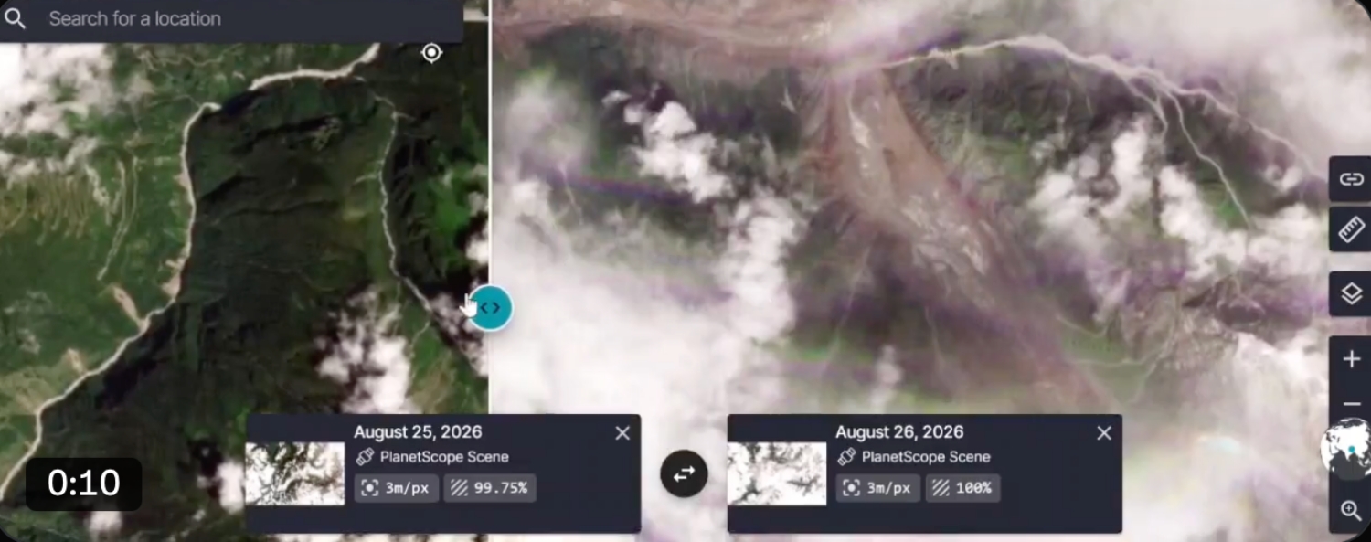
On 13 August, a landslide near Nyalam in China blocked the flow on the East Bhote Kosi. When the river level fell ominously, Nepali authorities warned downstream residents to remain alert, while security personnel monitored the river for a sudden surge.
There had been no warning about the river blockage. Satellite images sourced from Planet Labs show a landslide or ice avalanche (pictured) racing down to the Lhende River and blocking it.
An effective early-warning system is more than a message sent to a phone. The World Meteorological Organization (WMO) defines it as a chain connecting risk knowledge, monitoring and forecasting, communication, and preparedness to respond.
Nepal's own disaster-management institutions recognise this distinction. The National Disaster Risk Reduction and Management Authority (NDRRMA)'s 2024 report says Nepal is working on a multi-hazard early-warning system and impact-based action plans, while also acknowledging the need to strengthen coordination between government agencies, academic institutions, and other stakeholders.
A 2024 study of communities in the Bhote Kosi / Sun Kosi and Trisuli basins found a high level of awareness of GLOF risk along the Bhote Kosi and recommended stronger early-warning systems, cross-border cooperation, public awareness, and resilient infrastructure.
A Stimson Center assessment also notes that advances in remote sensing and earth observation make real-time monitoring of debris floods and extreme flow events technically feasible in Nepal. The question now is how do we connect all of this together.
Nepal has demonstrated its ability to respond when disaster strikes. On Wednesday, the Nepal Army, Armed Police Force, and Nepal Police were immediately mobilised. Army and private helicopters flew medevac missions, and warnings were issued downstream as floodwaters moved into the Trisuli system.
But rescue is necessarily reactive. By the time helicopters are in the air, bridges may already have been washed away, roads blocked, and communities stranded. Preparedness asks what could have been done before that point.
For the Bhote Kosi, that means reliable data-sharing with China, monitoring glacial lakes and unstable terrain, incorporating satellite and scientific research into government risk assessments, and establishing clear protocols for district authorities, hydropower operators, and communities when an upstream hazard is detected.
It also means reconsidering how Nepal rebuilds after disasters. The Betrawati–Rasuwagadi corridor, damaged by last year's flood, has again suffered extensive damage, with roads and bridges washed away.
Rebuilding the same infrastructure without incorporating new hazard information risks rebuilding the same vulnerability. Nepal cannot predict every flood. It cannot prevent glaciers from retreating or every landslide from occurring. But it can build a system in which an upstream disturbance triggers monitoring, information-sharing, risk assessment, and preparedness downstream.
The 2025 flood showed what happens when information cannot cross the border quickly enough. The 26 August flood has shown, once again, how quickly a hazard originating beyond Nepal can become a national disaster.
The question is no longer whether Nepal knows that the Bhote Kosi can flood. The question is whether Nepal will know soon enough to act the next time something changes upstream.
A warning that arrives after the river has already crossed the border is not really an early warning. It is an alert asking people to brace for the wall of debris coming down the gorge.