
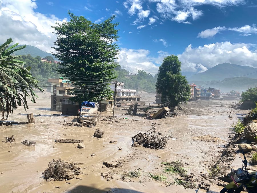
A major flood in Rasuwa on Wednesday morning on the Nepal-China border, the second in two years has proved once more that there are so many factors that have to be taken into account in forecasting weather disasters in the Himalaya.
Initial reports suggest a moderate-intensity earthquake triggered a landslide that blocked a river or caused a glacial collapse to unleash catastrophic flooding downstream.
This is a stark reminder that these mountains are the youngest, most unstable and fragile in the world. Add climate crisis and seismicity to the mix and it becomes Nepal’s objective reality.
Early this summer, Nepal was warned to brace for a weak and delayed monsoon. The Supercharged El Niño developing in the Pacific was expected to suppress rainfall across the Subcontinent, raising concerns about drought, water shortages and poor harvests.
Nepal’s Department of Hydrology and Meteorology issued forecasts of below-normal rainfall and above-normal temperatures. The monsoon itself arrived late, and for a while the warning seemed to be tracking.
Heavy downpours in the Rosi upstream catchment —around Phulchoki, Panauti, and Dhulikhel — have repeatedly sent floodwaters surging down to the BP Highway, sweeping away temporary diversions along the river that linked Kathmandu and eastern Nepal since the September 2024 floods destroyed an entire section of the road artery.
The contractor rebuilding those diversions captured the situation precisely: “The Rosi has not only washed away roads, it has also washed away government money.” As of mid-July, permanent reconstruction was still underway, with authorities now raising the road eight metres above the riverbed to escape the river’s reach.
The Bhote Kosi flood on Wednesday raced down the Trisuli to Mugling and Narayangad, prompting the government to close the Prithvi Highway to traffic. Bridges 50km downstream were washed away by the flood.
Earlier this month, nine highways across Nepal were blocked simultaneously by monsoon floods and landslides during a single week in July. In Panchthar, floods and landslides disrupted roads, swept away an under-construction bridge over the Tamor River, and damaged hydropower infrastructure — with the Jorpokhari–Memang road blocked since 20 July. The Jajarkot–Dolpa section of the Bheri Corridor was completely cut off, stranding vehicles midway between districts.
By mid-August, Nepal Police reported at least 85 deaths from monsoon disasters since April, across 19 districts. After Wednesday, the toll is now expected to rise into the hundreds.
DHM continued issuing moderate to heavy rainfall warnings for the hills of Kosi, Bagmati, Gandaki and Lumbini provinces simultaneously — while national accumulated rainfall approached what would be recorded as broadly normal.
Was the forecast wrong?
HYPERLOCAL FORECAST
Firstly, there is little early warning information sharing between China and Nepal. This has to be systematised so that people downstream know if there has been a glacial lake collapse or a cloudburst.
But even within Nepal, the DHM considers 90–110% of long-term monsoon rainfall to be normal. This year’s national figure is converging on that range. By that measure, the monsoon will be recorded as broadly normal.
But this single national number is only an average across four months and across a country that rises from the Gangetic plain to the high Himalaya. The Tarai, the Siwaliks, the Mahabharat range, and the high valleys do not experience the same atmospheric system in the same way.
A rainstorm that saturates Kavre may leave Sindhupalchok dry. An intense low-pressure system that drops 300mm on Myagdi in 48 hours disappears entirely from a four-month provincial average.
Think of it this way: two farmers, both in the same district, both receive what records show as ‘normal’ seasonal rainfall. The first farmer’s rain came steadily through June and July, recharging soil moisture and keeping paddy crops on schedule.
The second farmer received almost nothing through June — then 200mm in 72 hours in the last week of July, just as paddy was maturing. The seasonal total is identical. One farmer had a good year, the other lost the crop and watched the access road to her field wash out.
This is not a hypothetical. It describes what happened in Sindhuli, Okhaldhunga and Syangja — and in Rasuwa this week. And it illustrates why the word ‘normal’ can be deeply misleading when applied to Nepal's weather.
Weather prediction has improved enormously. The probability of correctly forecasting whether rain will occur on a given day is now around 90%. Satellite data, numerical modelling and regional cooperation have all contributed.
But forecasting systems still cannot reliably give a municipality, a ward or a farmer: a hyperlocal forecast that accounts for Nepal’s extreme terrain. And as the Bhote Kosi disaster showed once more: it is even more important to make meteorological and hydrological predictions transboundary.
Global numerical weather models resolve the atmosphere at grid boxes of roughly 10–25km. Nepal’s ridgelines, river gorges, rain-shadow valleys and slope aspects operate at a scale of hundreds of metres to a few kilometres.
The model does not see the difference between a windward slope and a leeward valley below it, even though those two places may receive three times as much or as little rain from the same storm system.
No seasonal forecast can tell Sun Kosi Rural Municipality whether its critical recharge zones will receive adequate rainfall to keep its springs flowing through the dry season. That requires local measurement.
INFRASTRUCTURE PLANNING
Here is the uncomfortable part for Nepal's development planners: We have been building water supply schemes, hydropower plants, irrigation systems and roads for decades without systematic local weather data.
We extrapolate from the nearest airport or district headquarters station — sometimes 30, 50 or 80km away from the project site, on completely different terrain.
A hydropower feasibility study conducted in Myagdi may rely on rainfall data from Pokhara airport. A rural water scheme in Okhaldhunga may be designed using flow estimates from a river gauge 60km downstream.
When those schemes underperform, or fail after a single extreme event, we call it climate change. Sometimes it is. But mostly it is simply that we never measured what we were building in.
Automatic weather stations (instruments that continuously record rainfall, temperature, humidity and wind) are no longer expensive pieces of equipment available only to national agencies.
A reasonable solar-powered station with a data logger now costs a fraction of what a municipality spends on a single road repair. Several municipalities in Nepal's foothills, including Belaka in Udayapur, have installed them in their compounds, schools and government offices. The data from even a handful of such stations would transform what a municipality can know about its own watershed.
Nepal has one more underused resource: the observational memory of its farming communities. In Sindhuli, there are farmers who can tell you which slope gets the first monsoon rain and which stays dry until late July.
They know that a particular spring takes approximately three weeks to respond after heavy rainfall in its upper catchment. They recognise a specific cloud formation over the hills to the east as the precursor to a damaging hailstorm. This knowledge has accumulated over generations of watching the same land.
It is not infallible. It does not replace instruments. But it is a form of spatial intelligence about local climate that no national model currently carries — and that is entirely absent from the feasibility studies, annual budgets and infrastructure designs that shape development in these places.
Schools could play a role here too: teachers who invite senior farmers into the classroom to share seasonal weather knowledge are doing something no textbook can replicate.
A municipal weather system worth building would weave these strands together: an automatic station for continuous measurement, satellite data to fill the gaps, DHM forecasts for regional context, and documented community observations for the hyperlocal detail no instrument network can fully cover.
The real limitation of Nepal's forecasting system is not that it failed to predict this monsoon. It is that we have built a planning culture that relies on national averages and seasonal outlooks to make decisions that are fundamentally local and immediate.
Farmers do not need to know whether Nepal will receive 90 or 110% of normal rainfall. They need to know whether the rain will come this week, in their watershed, with what intensity, and whether the slope is already saturated enough to be dangerous.
A municipality does not need a provincial forecast. It needs to know whether its critical river corridor will see a dangerous pulse of water in the next 48 hours, and which settlements should move to higher ground tonight.
Nepal cannot predict every raindrop. But it can — at relatively modest cost — know where the rain is falling, in real time, even if it is in China, at the scale where decisions are actually made.
That is not a meteorological ambition. It is a governance obligation.
Ngamindra Dahal is a water and climate adaptation practitioner based at the Nepal Water Conservation Foundation.