
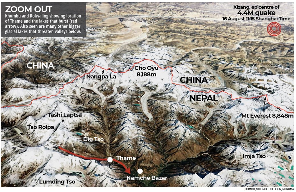
At exactly 9AM on 16 August, a 4.5M earthquake hit Xizang on the Tibetan Plateau. Four hours later, 65km away in Nepal, a glacial lake burst unleashing a cascade of destruction downstream.
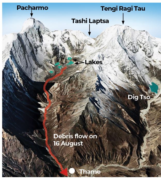
It is not certain if that tremor so nearby caused the lake to burst — either because an avalanche on the south ridge of Mt Tengi Ragi Tau fell into it, or heavy monsoon rain led to the collapse of a moraine.
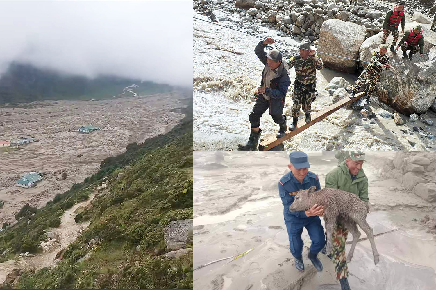
Either way, the snowmelt emptied into another lake below and unleashed a debris flow that roared down the valley to the village of Thame. Fortunately, children at a school had gone home early that Friday and inhabitants had time to climb to safety when they heard the approaching roar. There were no fatalities.
Thame was not as lucky on 4 August 1985, when a bigger lake in an adjacent valley, Dig Tso, burst after an avalanche fell on it. Twelve people were swept away by the ensuing flood, a newly built hydropower plant was destroyed, and a section of the Everest trekking trail was washed away.
Glaciologist Tenzing Chogyal Sherpa remembers his mother telling him that their home in Namche Bazaar was spared because it was on higher ground.
“But she told us that with trails destroyed, food and supplies couldn’t reach us. At one point, her family had to survive on rotten potatoes,” recalls Sherpa, who works at the Kathmandu-based International Centre for Integrated Mountain Development (ICIMOD) and uses remote sensing to map climate-induced hazards in the Himalaya.
He says the Thame flood this week was a reminder of the inherent risk of living in the mountains which are magnified by climate breakdown. And the region is still very much at risk.
“To the south, we have Lumding Tso, a potentially dangerous glacial lake that also empties into the Dudh Kosi, and to the west in Rolwaling is Tso Rolpa, a lake that is now 3km long. And to the north is Dig Tsho, which burst in 1985,” says Sherpa.
"We are facing one of the worst disasters since the Dig Tso flood. This is a wake-up call, not just for us in Khumbu, but for the entire Himalaya to rethink our ways, find alternatives to reduce the risks, and explore measures to protect ourselves," he adds.
The Thame flood was a smaller disaster compared to the flood that destroyed the Melamchi headworks in 2021, the massive Sikkim flood last year, or the debris flow that ravaged Kagbeni. All were caused by glacial lake bursts or moraine collapses due to extreme rainfall.
Anil Pokhrel of the National Disaster Risk Reduction and Management Authority (NDRRMA) flew to Thame on Saturday morning to inspect the glaciers above the village. He confirmed that two of five small glacial lakes below Tashi Lapcha pass had caused the flood. Satellite data shows that till two years ago, there were only four lakes.
Across the Himalaya, there are now thousands of new glacial lakes that do not even have names. In Nepal most of the 21 most dangerous ones are located in the centre and east of the country, but there are dozens of enlarged lakes in China which drain into tributaries of rivers that flow into Nepal like the two Bhote Kosis, Arun and Tama Kosi.
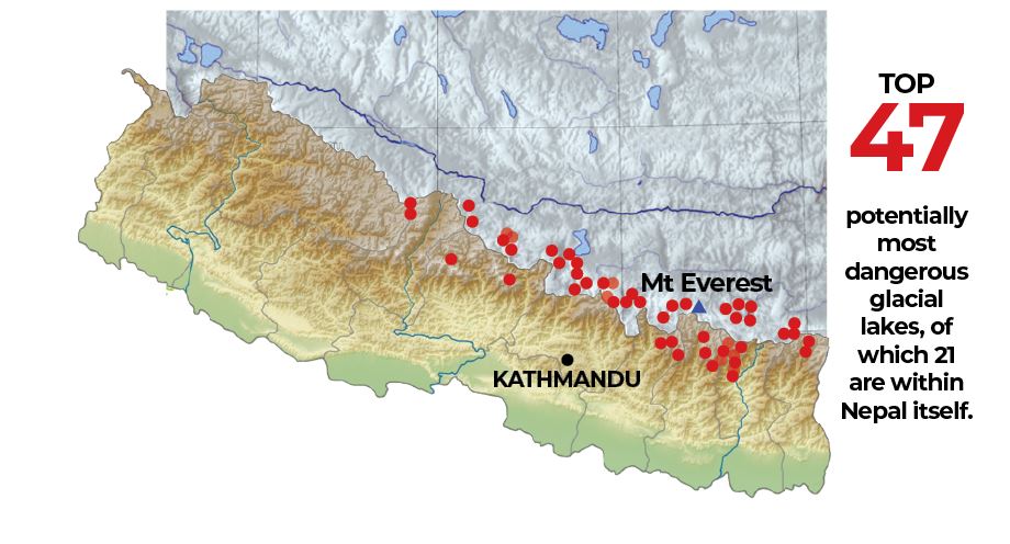
Some of these lakes are infamous because of their volume, the rate at which they are expanding, and the potential danger they pose to populations downstream — like Tso Rolpa, Imja Tso and Thulagi.
But the Thame flood, and others like the Nare Lake outburst below Ama Dablam in 1977 show that even smaller lakes can cause massive damage.
In fact, it does not even take a lake burst to cause destructive debris flows. The Melamchi and Kagbeni floods appear to have been caused by moraines that collapsed in unusually heavy rain because they were no longer cemented by permafrost.
Even a relatively small flood like the one in Thame can be damaging far downstream. The debris flow moved swiftly downstream, destroying a Rs80 million bridge on the Dudh Kosi in Okhaldhunga. Most villages downstream had been evacuated, so there were no casualties. If the flood had been bigger, it would have threatened major hydropower projects on the Dudh Kosi.
“We cannot ignore smaller lakes anymore,” warns Pokhrel of NDRRMA. “We often think and plan from a hazard perspective, how big a disaster can be. But we must also look at risk, possible cascade damage on downstream communities.”
Thame is at 3,840m elevation, but Pokhrel says he was surprised by how warm it was up there this week. “It felt like Kathmandu,” he says. “And satellite imagery shows accelerated melting of the upstream in the past month which could have led to the cascading collapse of the two lakes.”
Glacial lake outbursts and debris flows are going to be more destructive and frequent in Nepal in the coming years, making them a fact of life. Seismic risk in the Himalaya adds to the dangers posed by the climate emergency.
Local communities and governments have no option but to adapt by installing early warning systems, planning smaller decentralised hydropower schemes, moving settlements and infrastructure higher, and conducting detailed hazard mapping.
“Thame showed us we cannot only rely on satellite mapping, and why in-situ observation is so important in a country with such a diverse topography and climate as ours,” says Sherpa. “There are more than 50,000 glaciers in the Himalayan region and we haven’t even studied 1% of them.”
Despite the scarcity of field data, there have been considerable advances in remote sensing technologies that have helped fill this gap in data and help understand the changing cryosphere. ICIMOD’s recent report shows that glacier mass loss has increased by 65% in recent decades. The report also warns that the risk of flooding could increase much more in the coming century.
Because so many of Nepal’s rivers are transboundary, a bilateral early warning mechanism with China is also urgent. Because of the scale of the danger, Nepal needs resources from the international community for adaptation, as well as loss and damage reparation to cope with future risk.
“Our government needs to get in touch with the Chinese government to conduct a study of glacier lakes located near Tibet, which are the source of glaciers in Nepal. We should collaborate on early warning system and implementing risk reduction measures,” says Anil Pokhrel.
Tenzing Chogyal Sherpa co-founded a global advocacy campaign called #SaveOurSnow last year to provide local communities with agency to deal with climate induced risk. Supporters of the campaign include former new Zealand Prime Minister Helen Clark, celebrity mountaineers like Reinhold Messner, Chris Bonington, Kenton Cool and the descendants of Tenzing Norgay.
Says Sherpa: “As glaciers melt and lakes expand, disasters like Thame will be more frequent, we have to adapt. We need to tell our stories to the world, even as they continue to debate on the topic, we are already facing the brunt of it without having caused it ourselves. At local levels, we have to get back on our feet and prepare for what's coming.”