
The Kathmandu Valley civilisation can also be called a hydrological culture where sophisticated water management allowed densely-packed settlements to co-exist with intense agriculture on the fertile soil of the former lake-bed.
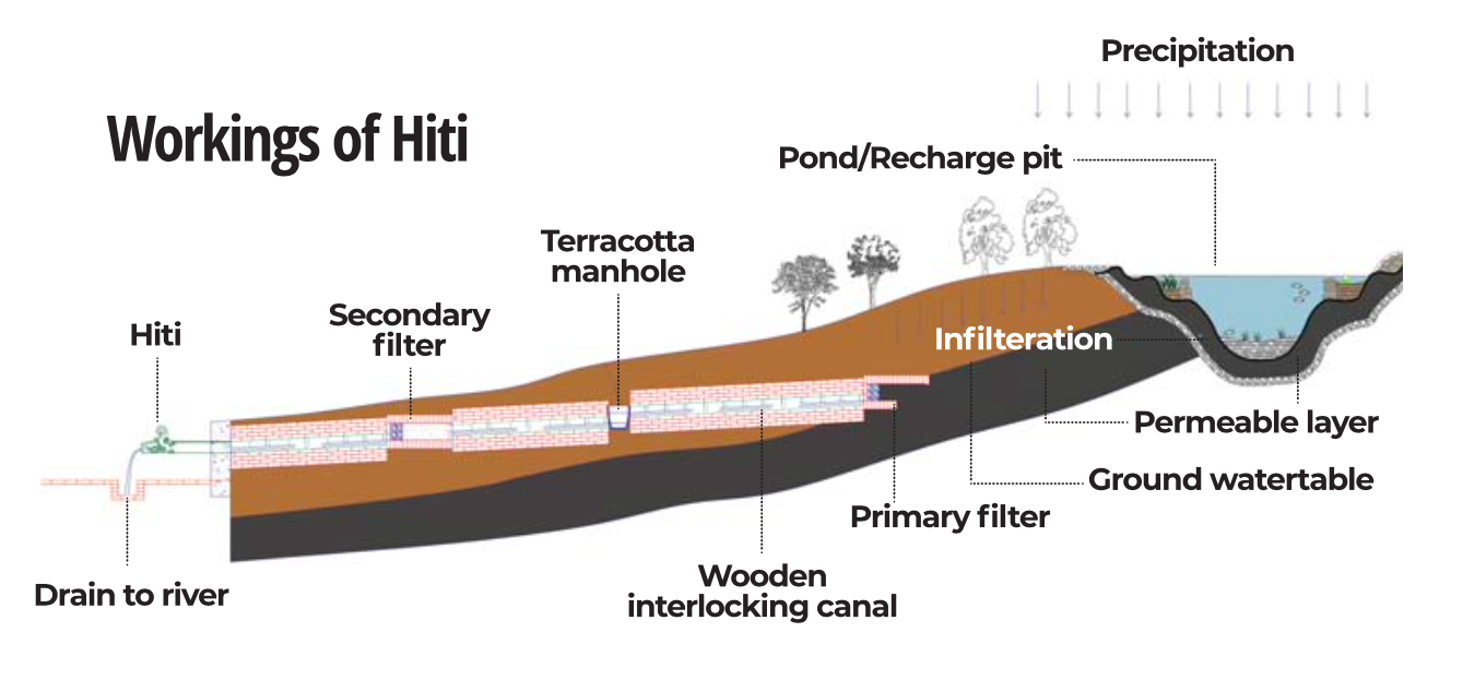
Both needed plenty of water, but the Valley’s rivers are not snowfed. So, the rulers of the kingdoms sourced them from the surrounding hills in an elaborate network of canals that did not just provide water for irrigation and fill ponds that recharged ground water, but also ensured urban supply through sunken spouts called hiti.
The fact that the hiti system is still a vital source of water for the residents of inner city Kathmandu, Patan or Bhaktapur despite rapid urbanisation is a testament to the engineering and planning expertise of our ancestors dating back to the Lichhavi period (400–750 CE) and later expanded during the Malla era (10th–18th century CE).
‘The Liquid Landscape of Kathmandu Valley: Hiti Pranali Water Heritage’ is a new exhibition at Patan Museum to pay tribute to this cultural heritage and explores recent archaeological research that offers solutions to not just their preservation but also to maintain them to supplement modern systems.
Read also: Saving Nepal’s hiti heritage
The research by Hayley Saul of Heritage for Global Challenges Research Centre and PhD scholar Anoj Khanal at the University of York in the UK entailed using Ground Penetration Radar (GPR) to generate electromagnetic waves to map underground water conduits. Collaborating in the research was engineer and author of the seminal book Hiti Pranali, Padma Sunder Joshi of the Madan Bhandari University of Science and Technology.
“We used GPR to explore if we can find filtration systems or functions that allow for the flow and control of water and its distribution,” Saul explained.
Although many of the historical monuments of the Valley that were destroyed in the 2015 earthquake have now been rebuilt, there has been minimal work in finding out about underground water conduits that may have been damaged, and in their restitution.
Read also: A portal into Patan’s past and present, Prakriti Kandel
GPR technology can be used to map the main canals (raj kulo) and their branches, explore how they were designed and built in the first place, without having to carry out expensive excavation -- which would be difficult anyway because much of the Valley floor is now built up.
Local governments can now use the data collected by the researchers to map out the network canals, enforce building restrictions if needed and to maintain them.
The hiti of Kathmandu were not just functional, but sacred and served as social and spiritual hubs. They provided water for drinking, laundry, household use, rituals, while also serving as gathering places for communities.
With the introduction of modern water mains from the late 19th century onwards and rapid urban growth, many hiti have fallen into disrepair or dried up. Of the at least 573 stone spouts once counted in Kathmandu Valley, many are lost, damaged, or no longer functional due to neglect, pollution, and encroachment of ponds and canals that feed them.
Joshi explains that Kathmandu’s ancient urban planners developed the hiti network after the kingdoms located to higher ground to leave the lower areas for agriculture. It forced them to devise ways to bring water through a network of canals fed by aquifiers, and use the gradient to sunken hiti stone spouts for distribution.
The exhibition at Patan Museum also demonstrates that the hiti system incorporates space for living beings, making it a self-functioning ecosystem in itself. The existence of plants such as ferns and algae, and snakes and frogs indicate a healthy ecosystem in the sunken spouts. Absence of such biodiversity today indicates that the water systems have been degraded or polluted.
“The ponds were used to collect water and recharge groundwater and aquifers,” explains Joshi. “They were primarily used for farming ducks which needed the algae in the ponds as food.”
Every June just before the monsoon, Kathmandu Valley’s Newa community ritually cleans wells and other sources of water to maintain drainage and ensure that they serve as effective storage systems. Which is why Kathmandu’s hydrological culture is such an important part of its civilisation to this day.
Read also: The Water Emergency, Ajaya Dixit
The underground network of water canals also showed advanced engineering skills, and the system was so well built that it has lasted centuries, even though local communities may have lost the skills needed to build and maintain them.
Says Anoj Khanal, “The wisdom from the past must be preserve and used. The technique and knowledge must be adapted to the modern times.” The York University team used the GPR technology at 33 hiti sites in Patan, and now hope to do similar research in Kathmandu.
The hiti system thrived because it worked in balance with nature which has been disrupted with modern pressures as over-extraction of ground water and the disappearance of recharge ponds. Pollution from septic tanks and industrial waste contaminate aquifers, while climate breakdown alter rainfall patterns. Many hiti that once flowed year-round are now dry even during the monsoon.
The hiti exhibition showcases the intricate heritage of Kathmandu Valley’s water supply network and how modern technology can help restore them. It is also a call to action to preserve the canals, spouts, ponds and the catchment areas on the Valley’s rim.
Says Khanal, “It is possible to revive the hiti using the maps of water conduits underground to figure out alternate routes where water can flow. It is better late than never.”
The Liquid Landscape of Kathmandu Valley: Hiti Pranali Water Heritage
Until 30 March
Patan Museum